| My Lightbox | Search |
 |
FILE 13131 of 44661 |  |
 |
 |
 |
|
|||
|
| File information | |
| Filename: | az-0584-d.jpg |
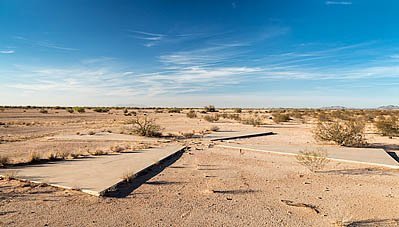
| Image Description: | Casa Grande, Arizona - One of 256 satellite calibration markers placed in the Arizona desert by the U.S. Air Force and the Central Intelligence Agency during the Cold War. The concrete markers helped calibrate spy satellites to take pictures over Russia and China from 1959 to 1972. |
| Lightbox: | Add to Lightbox |